Monday 17.01.2011
We got the van fixed today – twice. After breakfast we went to Maui’s service garage in Queenstown, where they fitted a new grey- water spout, replacing the one we broke yesterday. Then we drove off on highway 6 towards Cromwell and Wanaka We stopped at Arrowtown; an old prospecting town with a restored Chinese gold-mining village. Conditions for those who worked here were grim, to say the least.
We followed the Kawarau gorge and stopped near Giibbston to watch some insane people bungie jumping off a bridge.
Further downstream was the Roaring Meg rapids and hydro power station
there was a picnic site next to it so we stopped to have lunch in the shade of some eucalyptus trees. As we were pulling out we went down a pothole in the entrance and there was a loud clonk. We looked back to see our newly mended waste pipe lying on the floor, this time with its tap and bracket, and a big puddle of water where our tank was happily emptying itself. Rather than going back to Queenstown we looked through our handbook and found a garage in Wanaka. They did a much better repair and it now doesn’t drip like it did before. It still is in a very vulnerable place though, We’ll have to be extra careful how we turn off the road from now on or we’ll end up bashing it again.
In Wanaka we couldn’t resist Puzzling World; a big 3D maze and café.
There were dozens of little wooden puzzles on the tables and we had a brilliant time in the maze. The average time for finding all four towers in the right order and getting out again is an hour. With our combined genius we took 45 minutes, and were extremely pleased with ourselves.
We carried on up highway 6 alongside Lake Hewea with the scenery getting more dramatic every mile, the road then crosses a 500m pass back to Lake Wanaka; very dramatic. We stopped at a DOC campsite on the shore of this beautiful lake and were lulled to sleep by the waves washing the driftwood strewn beach.
Wednesday, 19 January 2011
Sunday, 16 January 2011
Te Anau & Milford Sound
Saturday 15.01.2011
We’d had breakfast and were ready and waiting outside the garage when it opened at 9am. With a full tank of diesel we headed due north on the edge of Fiordland; a vast uninhabited area in the bottom left hand corner of South Island full of mountains, lakes and unspoilt wilderness.
We had elevenses at Lake Manapouri then carried on up through Te Anau and into the mountains, heading for Milford Sound which lies at the end of Highway 94. The guidebook quoted 2 hours for the trip from Te Anau to Milford Sound; it took us about 5. We kept stopping to go “Wow!” and take photos.
Clifden
Blackmount
Eglinton River.
Mirror Lakes.
Lake Gunn, where we went for a walk.
Mt Christina lookout, where we had lunch.
The corrie at Homer Tunnel while we waited for the traffic lights to change. After the tunnel the road helter-skelters back down to sea level at Milford Sound so fast it makes your ears pop.
At the end of the road there are several car parks, an information centre, a café, an air-strip where the flights over the glaciers take off from, and a harbour and jetty for the scenic cruise ships. It was drizzling when we arrived so we went into the café for a Flat White and waited till it eased up a bit, then went for a short walk round the shore for a better view of the Sound
and this waterfall.
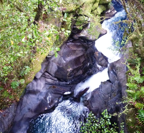
On the drive back toward Te Anau we stopped at The Chasm, a stunning waterfall. The 5 minute walk from the car park is along a beautifully maintained path which ends in a loop over 2 bridges spanning the top and bottom of the falls giving you the best view.
Kiwi tourism at its best. When we got to the tunnel it was after 6pm so the traffic lights weren’t working, luckily there wasn’t anything coming, so we got through without any screaming. We carried on down Highway 94, and stopped for the night at a proper camping ground at Harry Creek, right on the shore of Lake Te Anau. Very basic, but 10NZ$ (£5) for the night, and a view like this
and we had Bambi sausage, mash and red wine gravy for tea.
Result!
We’d had breakfast and were ready and waiting outside the garage when it opened at 9am. With a full tank of diesel we headed due north on the edge of Fiordland; a vast uninhabited area in the bottom left hand corner of South Island full of mountains, lakes and unspoilt wilderness.
We had elevenses at Lake Manapouri then carried on up through Te Anau and into the mountains, heading for Milford Sound which lies at the end of Highway 94. The guidebook quoted 2 hours for the trip from Te Anau to Milford Sound; it took us about 5. We kept stopping to go “Wow!” and take photos.
Clifden
Blackmount
Eglinton River.
Mirror Lakes.
Lake Gunn, where we went for a walk.
Mt Christina lookout, where we had lunch.
The corrie at Homer Tunnel while we waited for the traffic lights to change. After the tunnel the road helter-skelters back down to sea level at Milford Sound so fast it makes your ears pop.
At the end of the road there are several car parks, an information centre, a café, an air-strip where the flights over the glaciers take off from, and a harbour and jetty for the scenic cruise ships. It was drizzling when we arrived so we went into the café for a Flat White and waited till it eased up a bit, then went for a short walk round the shore for a better view of the Sound
and this waterfall.
On the drive back toward Te Anau we stopped at The Chasm, a stunning waterfall. The 5 minute walk from the car park is along a beautifully maintained path which ends in a loop over 2 bridges spanning the top and bottom of the falls giving you the best view.
Kiwi tourism at its best. When we got to the tunnel it was after 6pm so the traffic lights weren’t working, luckily there wasn’t anything coming, so we got through without any screaming. We carried on down Highway 94, and stopped for the night at a proper camping ground at Harry Creek, right on the shore of Lake Te Anau. Very basic, but 10NZ$ (£5) for the night, and a view like this
and we had Bambi sausage, mash and red wine gravy for tea.
Result!
Dunedin to Tuatapere
Thursday 13.01.2011
We left Dunedin on the coast road in the morning, stopping for elevenses at Brighton. We caught up with Highway 1 again and followed the Southern Scenic Route. This is well signed and really shows off the best of the lower South Island. It leaves Highway 1 at Balclutha where we did a bit of shopping, and goes right round the Catlins Conservation Area on its way to Invercargill. We took a diversion off to Molyneux Bay
and had lunch at Kaka Point looking out over a very fierce looking Pacific. In the afternoon we followed the signs to Nugget Point, where we saw some spoonbills nesting on in the incredibly steep cliffs with some more fur seals on the rocks at the bottom. We had a windswept walk out along the path to the lighthouse.
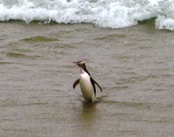
There was a Yellow Eyed Penguin colony on the other side of the headland; the information board said that the best time to see them was after 4pm. Guess what? Yep. On the dot. We walked down to the hide and looked out of the window. As if we’d ordered it a solitary penguin had just come out of the water and was standing on the beach preening itself.
Just before we left it was joined by another one. These are about 3 times the size of the little Blue Penguins, but just as cute.
Back on the SSR we carried on towards Invercargill, turning off to have a look at Porpoise Bay. A little way down this very quiet road we came to the township of Waikawa where there was a mobile fish & chip shop next to a car park with some public loos. We can take a hint. After we pulled in we were joined by 2 more vans with the same idea. Very peaceful night.
Friday 14.01.2011
We continued down the Porpoise Bay road to Curio Bay and finally a car park where we left Kiwi Ken and followed a path to Slope Point; the most southerly point of South Island. There’s nothing between here and Antarctica except stormy seas.
We finally got into Invercargill just after 12. We found a dump point and washed out then parked up and had lunch. Later on we went for a quick look round, bought a camping toaster (crumpets for breakfast. Mmmm!) and had a coffee in McWifi. Ann-Marie managed to transfer our unresponsive e-mail account from Live to G-mail and got it working. She’s a star! We can now get back in touch with everyone, except that we reached the download limit so it will have to wait till next time.
From Invercargill we headed west, again following the SSR, this time on Highway 99, round the Longwood Mountains and the Longwood Forest Conservation Area. We got to Tuatapere at 6.20; the petrol station shut at 6. Because we’d only got ¼ of a tank left and the next place we were sure would have diesel was over 100km away we thought it best if we stayed put for the night. We did have a little drive out on some gravel roads to a couple of local beaches
but there wasn’t anywhere to park so we returned to the town and stopped on the side of the road near the loos.
We left Dunedin on the coast road in the morning, stopping for elevenses at Brighton. We caught up with Highway 1 again and followed the Southern Scenic Route. This is well signed and really shows off the best of the lower South Island. It leaves Highway 1 at Balclutha where we did a bit of shopping, and goes right round the Catlins Conservation Area on its way to Invercargill. We took a diversion off to Molyneux Bay
and had lunch at Kaka Point looking out over a very fierce looking Pacific. In the afternoon we followed the signs to Nugget Point, where we saw some spoonbills nesting on in the incredibly steep cliffs with some more fur seals on the rocks at the bottom. We had a windswept walk out along the path to the lighthouse.
There was a Yellow Eyed Penguin colony on the other side of the headland; the information board said that the best time to see them was after 4pm. Guess what? Yep. On the dot. We walked down to the hide and looked out of the window. As if we’d ordered it a solitary penguin had just come out of the water and was standing on the beach preening itself.
Just before we left it was joined by another one. These are about 3 times the size of the little Blue Penguins, but just as cute.
Back on the SSR we carried on towards Invercargill, turning off to have a look at Porpoise Bay. A little way down this very quiet road we came to the township of Waikawa where there was a mobile fish & chip shop next to a car park with some public loos. We can take a hint. After we pulled in we were joined by 2 more vans with the same idea. Very peaceful night.
Friday 14.01.2011
We continued down the Porpoise Bay road to Curio Bay and finally a car park where we left Kiwi Ken and followed a path to Slope Point; the most southerly point of South Island. There’s nothing between here and Antarctica except stormy seas.
We finally got into Invercargill just after 12. We found a dump point and washed out then parked up and had lunch. Later on we went for a quick look round, bought a camping toaster (crumpets for breakfast. Mmmm!) and had a coffee in McWifi. Ann-Marie managed to transfer our unresponsive e-mail account from Live to G-mail and got it working. She’s a star! We can now get back in touch with everyone, except that we reached the download limit so it will have to wait till next time.
From Invercargill we headed west, again following the SSR, this time on Highway 99, round the Longwood Mountains and the Longwood Forest Conservation Area. We got to Tuatapere at 6.20; the petrol station shut at 6. Because we’d only got ¼ of a tank left and the next place we were sure would have diesel was over 100km away we thought it best if we stayed put for the night. We did have a little drive out on some gravel roads to a couple of local beaches
but there wasn’t anywhere to park so we returned to the town and stopped on the side of the road near the loos.
Friday, 14 January 2011
Lake Tekapo to Dunedin
***We can't get onto our E-mail at the moment. We are trying to resolve it and will be back on line ASAP.***
After breakfast we had a walk around Pleasant Point, which didn’t take long, but did include a visit to Legends Café and a taste of their “World Famous Custard Square” Yum!
We carried on along Highway 8 to Lake Tekapo, with the scenery getting more dramatic with every mile. The lake is a beautiful light turquoise colour from powdered rock washed down from the glacier. At the bottom end is the Church Of The Good Shepherd, which is a popular place for Kiwis to get married.
It was a bit warm in the afternoon, so we had a siesta and about 4.30 began the climb up Mt John. At the top is the Earth and Sky Observatory, the Astro Café and the most amazing views out over Mt Cook and the Southern Alps.
The café shut at 6 and we were just in time to get a Flat White (NZ for Very Frothy Coffee). We came back down the long way along the lake shore.
Starting with Lake Tekapo, there are 8 hydro plants in this part of NZ, all linked together by man-made canals.
On its trip from the glaciers to the sea each drop of water is used to make power 8 times. We followed the hydro canal to the next lake on the power chain, Lake Pukaki, and stopped at the information center car park for the night.
From here there is a perfect view straight up the lake to Mt Cook, but when we arrived - just before dusk - it was covered in low cloud. It was still hidden in the morning but before we pulled out the summit appeared above the cloud layers.
Tuesday 11.01.2011
We had to find a doctor today. Dave has been trying to pretend that he hasn’t got a tooth abscess for a couple of days; he now looks like he’s hiding a lollypop and wincing a lot. Our first stop was the Medical Centre at Twizel, but they didn’t have an appointment till 4.30, and advised us to find somewhere in Oamaru as we were going that way. We stuffed Hamster-boy full of pain-killers and set off down the beautiful Waitaki valley.
In Oamaru we found Dr Woods, the duty MD for visitors, who prescribed some penicillin. Hopefully that’ll sort him out. We spent the rest of the afternoon walking through town and trying to get into our Hotmail account in McWifi. Windows Live doesn’t want to play at the moment, so our only contact with the outside world is through Facebook. Grrrr.
Just round the corner from Oamaru harbour is a Blue Penguin colony; they come home from the sea at dusk so we found a suitable night stop, then drove up to a lookout point for tea and back down again at 9pm when the viewing centre opened. It was very well organised; there’s a grandstand looking out over the beach, we were told all about their habits and habitat, then just as it was getting dark, waves of little Pingus started swimming ashore and waddling up the beach to their houses in the rocks. It was fascinating to watch; especially as they were there because they chose to be. Nobody trained them, they’re wild animals doing what they want, despite, not because of us.
Wednesday 12.01.2011
South along Highway 1. Stopped at Moeraki and looked at the boulders.
These are massive rock crystals that formed in the mud over millions of years and have been exposed by sea erosion. They look as if they’ve been washed up on the shore, or laid by some pre-historic chicken. We carried on to Shag Point for lunch where we walked out to the headland in the howling wind and watched a colony of Fur Seals basking in the (not very sunny) sunshine.
We could have spent all day watching them messing about, but the rest of NZ would have got jealous so we carried on.
At Dunedin we had a washout and then drove out the long and winding road to the end of the Otago Peninsula. Right at the tip is the Royal Albatross Centre and we wandered round the headland pointing our cameras skywards as big graceful birds circled above us.
The Centre is a purpose built establishment with lots of information, guided tours, a café and plenty of parking; pretty much the norm for NZ, they do take their wildlife and their visitors extremely seriously. We have been enormously impressed by how easy it is to be a tourist here. Kiwis are so friendly and you constantly get the feeling that someone has gone to a lot of effort to make you feel welcome everywhere you go. Every little town has well signed public toilets; there are camper-van dump stations all over the place and the road signs are clear and consistent, even on the unsealed minor roads.
There was no camping allowed on the peninsula, (we didn’t expect there would be, it would be full of camper-vans otherwise) so we drove back to Dunedin along the aptly named Highcliff Road.
There was a free car park by the harbour with a public loo so we stopped there for the night. We had a walk into town in the evening, took photos of the railway station, (apparently there’s a law which says you have to)
then walked round the Octagon in the centre, before retiring to Kiwi Ken for supper and bed. Dave is responding to the drugs, although he still answers to “Lumpy”. When we got back we discovered that just over the road there was a railway shunting yard with a night shift; it can’t have been that bad though, we didn’t wake up till 9am.
After breakfast we had a walk around Pleasant Point, which didn’t take long, but did include a visit to Legends Café and a taste of their “World Famous Custard Square” Yum!
We carried on along Highway 8 to Lake Tekapo, with the scenery getting more dramatic with every mile. The lake is a beautiful light turquoise colour from powdered rock washed down from the glacier. At the bottom end is the Church Of The Good Shepherd, which is a popular place for Kiwis to get married.
It was a bit warm in the afternoon, so we had a siesta and about 4.30 began the climb up Mt John. At the top is the Earth and Sky Observatory, the Astro Café and the most amazing views out over Mt Cook and the Southern Alps.
The café shut at 6 and we were just in time to get a Flat White (NZ for Very Frothy Coffee). We came back down the long way along the lake shore.
Starting with Lake Tekapo, there are 8 hydro plants in this part of NZ, all linked together by man-made canals.
On its trip from the glaciers to the sea each drop of water is used to make power 8 times. We followed the hydro canal to the next lake on the power chain, Lake Pukaki, and stopped at the information center car park for the night.
From here there is a perfect view straight up the lake to Mt Cook, but when we arrived - just before dusk - it was covered in low cloud. It was still hidden in the morning but before we pulled out the summit appeared above the cloud layers.
Tuesday 11.01.2011
We had to find a doctor today. Dave has been trying to pretend that he hasn’t got a tooth abscess for a couple of days; he now looks like he’s hiding a lollypop and wincing a lot. Our first stop was the Medical Centre at Twizel, but they didn’t have an appointment till 4.30, and advised us to find somewhere in Oamaru as we were going that way. We stuffed Hamster-boy full of pain-killers and set off down the beautiful Waitaki valley.
In Oamaru we found Dr Woods, the duty MD for visitors, who prescribed some penicillin. Hopefully that’ll sort him out. We spent the rest of the afternoon walking through town and trying to get into our Hotmail account in McWifi. Windows Live doesn’t want to play at the moment, so our only contact with the outside world is through Facebook. Grrrr.
Just round the corner from Oamaru harbour is a Blue Penguin colony; they come home from the sea at dusk so we found a suitable night stop, then drove up to a lookout point for tea and back down again at 9pm when the viewing centre opened. It was very well organised; there’s a grandstand looking out over the beach, we were told all about their habits and habitat, then just as it was getting dark, waves of little Pingus started swimming ashore and waddling up the beach to their houses in the rocks. It was fascinating to watch; especially as they were there because they chose to be. Nobody trained them, they’re wild animals doing what they want, despite, not because of us.
Wednesday 12.01.2011
South along Highway 1. Stopped at Moeraki and looked at the boulders.
These are massive rock crystals that formed in the mud over millions of years and have been exposed by sea erosion. They look as if they’ve been washed up on the shore, or laid by some pre-historic chicken. We carried on to Shag Point for lunch where we walked out to the headland in the howling wind and watched a colony of Fur Seals basking in the (not very sunny) sunshine.
We could have spent all day watching them messing about, but the rest of NZ would have got jealous so we carried on.
At Dunedin we had a washout and then drove out the long and winding road to the end of the Otago Peninsula. Right at the tip is the Royal Albatross Centre and we wandered round the headland pointing our cameras skywards as big graceful birds circled above us.
The Centre is a purpose built establishment with lots of information, guided tours, a café and plenty of parking; pretty much the norm for NZ, they do take their wildlife and their visitors extremely seriously. We have been enormously impressed by how easy it is to be a tourist here. Kiwis are so friendly and you constantly get the feeling that someone has gone to a lot of effort to make you feel welcome everywhere you go. Every little town has well signed public toilets; there are camper-van dump stations all over the place and the road signs are clear and consistent, even on the unsealed minor roads.
There was no camping allowed on the peninsula, (we didn’t expect there would be, it would be full of camper-vans otherwise) so we drove back to Dunedin along the aptly named Highcliff Road.
There was a free car park by the harbour with a public loo so we stopped there for the night. We had a walk into town in the evening, took photos of the railway station, (apparently there’s a law which says you have to)
then walked round the Octagon in the centre, before retiring to Kiwi Ken for supper and bed. Dave is responding to the drugs, although he still answers to “Lumpy”. When we got back we discovered that just over the road there was a railway shunting yard with a night shift; it can’t have been that bad though, we didn’t wake up till 9am.
Tuesday, 11 January 2011
Canterbury Plains to the coast.
Saturday 07.01.2011
We left the Top 10 Camping Ground at about 9am, drove back along Highway 75 to Christchurch, found a big supermarket and a Mc-wifi, and then went back into Maui Campervans to have our table fixed. In the afternoon we drove in the opposite direction towards the Southern Alps and Mount Hutt. One of the many free guides that we’ve picked up since we arrived has a 14 day itinerary that goes right round the south island and covers most of the best bits. We’re going to modify it a bit to end at Picton where we catch the ferry to North Island. We followed Highways 73 and 72 across the Canterbury plains
with sheep, cows and venison farms all around us
and then over the Rakaia River. When we hired the van they gave us a “Tourism Radio”; a GPS based device that plays through the car audio and gives you information on whichever part of the country you are travelling through. As we approached the bridge, it told us about a walk along the Rakaia River Gorge, so we pulled into the picnic area and went to stretch our legs. Like all the other rivers we’ve seen, the Rakaia is nowhere near as big as it is during the spring melt, but even in its reduced summer state it’s still quite formidable, and due to the clay that it has brought down from the mountains looks like very thin grey paint.
We walked along the path for an hour or so before driving on to Methven for the night. Methven is best known as a skiing base in the winter, at this time of the year it’s very quiet. We parked in a side street not far from the public loo and had a very peaceful night.
Sunday 08.01.2011
We left Methven and carried on along Scenic Route 72 towards Geraldine. At Mt Somers, the Bingy-Bongy Woman (as we’ve named the voice of Tourism Radio,) told us that there was a turning to Clearwater Lake. Not wanting to let her down we followed it and it took us about 20kms up an unsealed road into the mountains. At the end there was, sure enough, Camp and Clearwater Lakes, and a sort of shanty town made up of holiday homes. We had a walk along the shore, watching the waterskiing, and looking at the amazing scenery.
If we’d carried on up the track we would have got to Mt Potts, the film location of Edoras, the fortress city of the Rohan people, but we came back down and carried on into Geraldine where we had lunch.
We spent the afternoon in Timaru on the east coast, paddling in the Pacific
and with a happy dose of serendipity, watched the final concert of the 100th Caroline Bay Carnival.
Not wanting to stay in the town for the night, we headed out on Highway 8. Ann-Marie found a little town on the map called Pleasant Point. The sign said “The Name Says It All” so we pulled in for the night.
We left the Top 10 Camping Ground at about 9am, drove back along Highway 75 to Christchurch, found a big supermarket and a Mc-wifi, and then went back into Maui Campervans to have our table fixed. In the afternoon we drove in the opposite direction towards the Southern Alps and Mount Hutt. One of the many free guides that we’ve picked up since we arrived has a 14 day itinerary that goes right round the south island and covers most of the best bits. We’re going to modify it a bit to end at Picton where we catch the ferry to North Island. We followed Highways 73 and 72 across the Canterbury plains
with sheep, cows and venison farms all around us
and then over the Rakaia River. When we hired the van they gave us a “Tourism Radio”; a GPS based device that plays through the car audio and gives you information on whichever part of the country you are travelling through. As we approached the bridge, it told us about a walk along the Rakaia River Gorge, so we pulled into the picnic area and went to stretch our legs. Like all the other rivers we’ve seen, the Rakaia is nowhere near as big as it is during the spring melt, but even in its reduced summer state it’s still quite formidable, and due to the clay that it has brought down from the mountains looks like very thin grey paint.
We walked along the path for an hour or so before driving on to Methven for the night. Methven is best known as a skiing base in the winter, at this time of the year it’s very quiet. We parked in a side street not far from the public loo and had a very peaceful night.
Sunday 08.01.2011
We left Methven and carried on along Scenic Route 72 towards Geraldine. At Mt Somers, the Bingy-Bongy Woman (as we’ve named the voice of Tourism Radio,) told us that there was a turning to Clearwater Lake. Not wanting to let her down we followed it and it took us about 20kms up an unsealed road into the mountains. At the end there was, sure enough, Camp and Clearwater Lakes, and a sort of shanty town made up of holiday homes. We had a walk along the shore, watching the waterskiing, and looking at the amazing scenery.
If we’d carried on up the track we would have got to Mt Potts, the film location of Edoras, the fortress city of the Rohan people, but we came back down and carried on into Geraldine where we had lunch.
We spent the afternoon in Timaru on the east coast, paddling in the Pacific
and with a happy dose of serendipity, watched the final concert of the 100th Caroline Bay Carnival.
Not wanting to stay in the town for the night, we headed out on Highway 8. Ann-Marie found a little town on the map called Pleasant Point. The sign said “The Name Says It All” so we pulled in for the night.
Sunday, 9 January 2011
Jet-lagged and Gob-smacked!
Thursday 05.01.2011.
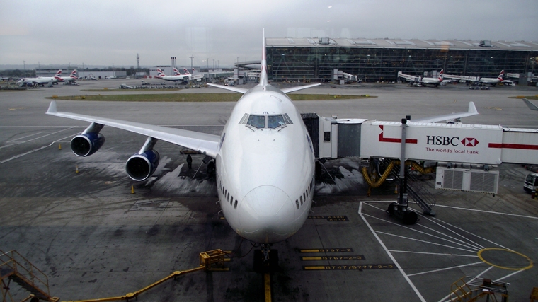
Well, here we are on the other side of the world. The international flights were long and tiring, but happily uneventful. We spent most of the time watching films and trying to sleep. Somehow we’d got it into our heads that we were going via San Francisco, so it was a bit of a surprise when our 747 landed in LA.
The domestic flight from Auckland down to Christchurch on the South Island was a bit more interesting; very bumpy going in, but the pilot got us on the ground in one piece. We got a shuttle to the hotel; the driver was really friendly and spent the entire journey pointing out places of interest. Finally, at 3pm we lay down on a bed for the first time in 44 hours. We think we did ok considering we’ve both got colds. By the way, descending from 35000’ when you’ve got blocked sinuses is not funny. It’s even less funny when you do it three times.
After an afternoon nap we dressed in summer attire, had a walk round Christchurch and immediately fell in love with it. It’s a beautiful, clean, friendly city. The streets are set out in a grid and from every intersection you can look south and see the mountains.
There’s a tram service with old fashioned street-cars on it, one of which is a restaurant. On the west side there’s a park that’s as big as the city itself with a botanical garden, and through it all winds the River Avon with the odd rowing boat and punt to complete the picture.
We got a bite to eat and went to bed jet-lagged but happy.
Friday 06.01.2011.
Unsurprisingly we were awake at 6am, so we had another walk round Christchurch, which looked even more lovely in daylight. We bought savoury muffins for breakfast from a little bakery and returned to the hotel to repack our bags and get the shuttle to Maui Campervans where we collected our home for the next 5 weeks. This time the driver told us all about the 7.4 earthquake that happened here here while we were in France. Quite a few of the older houses suffered damage; mostly pointy bits and chimneys falling down, but there are one or two empty plots where the building was demolished. A small part of the city centre has been cordoned off around an old department store with half its roof missing, and in the urban areal other places are fenced off, either to be repaired or pulled down. All the modern buildings survived, and,amazingly, although it happened at 4am, no-one was killed.
Our campervan is about as different to Ken as you could imagine. It’s a Toyota Hi-ace, less than a year old and automatic; an absolute breeze to drive.
In the back there’s a comfy enough bed, but because it’s designed to be hired it’s very basic and there isn’t much storage space. It has got a big fridge though. No doubt we’ll learn to live with it. For our first night we set off east onto the Banks Peninsula towards Akaroa.
This area was formed by two volcanic craters forming a natural harbour. It was the only attempt by the French to establish a settlement in NZ and still has a French flavour in the architecture and street names. The roads are fabulous and Kiwi Ken just lapped them up. (We’re not going to use the phrase “the views were fantastic”. Instead, it can be inserted into this blog by the reader at any point during the next 35 days.)
We stayed on a camp site for our first night, had a walk into town, wandered around the harbour and had excellent fish & chips for tea.
Well, here we are on the other side of the world. The international flights were long and tiring, but happily uneventful. We spent most of the time watching films and trying to sleep. Somehow we’d got it into our heads that we were going via San Francisco, so it was a bit of a surprise when our 747 landed in LA.
The domestic flight from Auckland down to Christchurch on the South Island was a bit more interesting; very bumpy going in, but the pilot got us on the ground in one piece. We got a shuttle to the hotel; the driver was really friendly and spent the entire journey pointing out places of interest. Finally, at 3pm we lay down on a bed for the first time in 44 hours. We think we did ok considering we’ve both got colds. By the way, descending from 35000’ when you’ve got blocked sinuses is not funny. It’s even less funny when you do it three times.
After an afternoon nap we dressed in summer attire, had a walk round Christchurch and immediately fell in love with it. It’s a beautiful, clean, friendly city. The streets are set out in a grid and from every intersection you can look south and see the mountains.
There’s a tram service with old fashioned street-cars on it, one of which is a restaurant. On the west side there’s a park that’s as big as the city itself with a botanical garden, and through it all winds the River Avon with the odd rowing boat and punt to complete the picture.
We got a bite to eat and went to bed jet-lagged but happy.
Friday 06.01.2011.
Unsurprisingly we were awake at 6am, so we had another walk round Christchurch, which looked even more lovely in daylight. We bought savoury muffins for breakfast from a little bakery and returned to the hotel to repack our bags and get the shuttle to Maui Campervans where we collected our home for the next 5 weeks. This time the driver told us all about the 7.4 earthquake that happened here here while we were in France. Quite a few of the older houses suffered damage; mostly pointy bits and chimneys falling down, but there are one or two empty plots where the building was demolished. A small part of the city centre has been cordoned off around an old department store with half its roof missing, and in the urban areal other places are fenced off, either to be repaired or pulled down. All the modern buildings survived, and,amazingly, although it happened at 4am, no-one was killed.
Our campervan is about as different to Ken as you could imagine. It’s a Toyota Hi-ace, less than a year old and automatic; an absolute breeze to drive.
In the back there’s a comfy enough bed, but because it’s designed to be hired it’s very basic and there isn’t much storage space. It has got a big fridge though. No doubt we’ll learn to live with it. For our first night we set off east onto the Banks Peninsula towards Akaroa.
This area was formed by two volcanic craters forming a natural harbour. It was the only attempt by the French to establish a settlement in NZ and still has a French flavour in the architecture and street names. The roads are fabulous and Kiwi Ken just lapped them up. (We’re not going to use the phrase “the views were fantastic”. Instead, it can be inserted into this blog by the reader at any point during the next 35 days.)
We stayed on a camp site for our first night, had a walk into town, wandered around the harbour and had excellent fish & chips for tea.
Subscribe to:
Posts (Atom)
Newbold to Stoke on Trent. North Oxford Canal. Coventry Canal. Trent and Mersey Canal.
When we got back from our camping trip Legend was exactly as we left it at Newbold and just as wet, but it was too late to light the fire, s...
-
South Oxford Canal. Cropredy to Aynho Wharf. Water, in it ’s various forms, continued to play an important role in our movements as we ...
-
When we got back from our camping trip Legend was exactly as we left it at Newbold and just as wet, but it was too late to light the fire, s...
-
Hermatage Lock at Earith is one of the two manned locks on the Ouse, the other being at Denver. This is because both are tidal. ‘Surely,’...